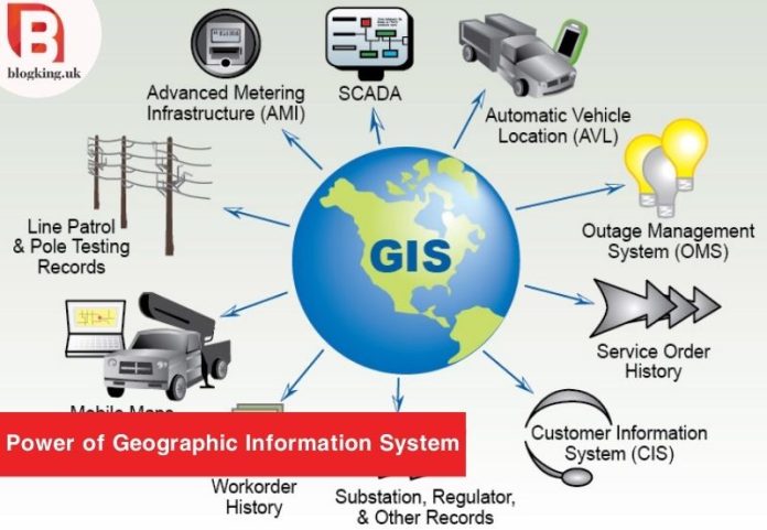
In today’s rapidly evolving technological landscape, Geographic Information System (GIS) stands as a beacon of innovation, shaping the way we perceive, analyze, and utilize spatial data. Whether you are an urban planner, environmental scientist, or a technology enthusiast, understanding GIS opens doors to many opportunities. Let’s delve into the world of Geographic Information System and explore how it transforms data into actionable insights, making our world brighter and more connected.
Table of Contents
Understanding Geographic Information System
At its core, a Geographic Information System is a framework that captures, stores, analyzes, and visualizes spatial or geographical data. It combines hardware, software, and data to provide valuable insights into various phenomena. A fundamental aspect of GIS is the Geographic Coordinate System, a reference system that enables precise location determination on the Earth’s surface.
Exploring Online GIS Solutions
In recent years, the advent of online GIS solutions has revolutionized the way we interact with geographic data. Online GIS platforms, also known as Online Geographic Information System, have become indispensable tools for professionals and enthusiasts alike. These platforms offer unparalleled accessibility, allowing users to access GIS capabilities directly from their web browsers. The convenience of real-time data updates and collaborative features makes the Online Geographic Information System a game-changer in diverse fields. By embracing Online GIS, individuals and organizations can streamline their workflows and make informed decisions efficiently.
Geospatial Information System in Practice
In practice, Geographic Information System finds applications in a multitude of sectors. Urban planners leverage GIS to design sustainable cities, optimizing infrastructure and resources. Environmental scientists employ GIS to monitor ecosystems, track wildlife, and manage natural resources. During disaster response efforts, Geographic Information System technology aids in efficient resource allocation and real-time decision-making. The applications are limitless, showcasing the versatility of GIS in addressing real-world challenges.
A Leading Solution for Geographic Information Systems
Among the array of GIS solutions, ESRI Geographic Information System stands out as a leading player. ESRI, Environmental Systems Research Institute, offers cutting-edge GIS software that empowers users to create, manage, analyze, and display spatial data. ESRI’s GIS solutions cater to various industries, ranging from government agencies to private enterprises. By utilizing ESRI’s technology, professionals can unlock the full potential of geospatial data, driving innovation and progress.
Geographic Information System and Geographical Mapping
The synergy between Geographic Information System and geographical mapping is undeniable. Geographic Information Systems enhance the accuracy and efficiency of geographical mapping processes. Cartographers and map enthusiasts leverage GIS technology to create detailed, interactive maps that serve diverse purposes. Whether it’s visualizing demographic data, analyzing land use patterns, or mapping natural features, GIS-enabled maps provide a comprehensive view of our surroundings. This integration of Geographic Information System and geographical mapping ensures that the maps we rely on for navigation and decision-making are informative but also precise and reliable.
The Far-reaching Impact of Geographic Information System
Informed Decision-Making
GIS provides accurate and real-time spatial data, enabling businesses, governments, and organizations to make well-informed decisions. Whether it’s urban planning, disaster management, or market analysis, Geographic Information System equips decision-makers with valuable insights, leading to more effective strategies and policies.
Efficient Resource Management
One of GIS’s notable impacts is its ability to optimize resource management. From agriculture to water supply, the Geographic Information System helps in the efficient allocation and utilization of resources, minimizing waste and maximizing productivity. This has substantial economic and environmental benefits.
Enhanced Public Services
Geographic Information System enhances the delivery of public services. Urban areas benefit from improved city planning, better transportation networks, and optimized emergency response systems. GIS-powered mapping applications provide citizens with valuable information, empowering them to navigate their surroundings and access essential services effortlessly.
Environmental Conservation
GIS technology aids environmentalists and conservationists in preserving natural habitats and biodiversity. By mapping ecosystems, tracking deforestation, and monitoring wildlife migration patterns, the Geographic Information System contributes significantly to environmental conservation efforts. It enables scientists to study climate change, facilitating the development of sustainable practices to protect our planet.
Advancements in Healthcare
GIS plays a vital role in healthcare management. It helps in disease mapping, resource allocation, and healthcare planning. Geographic Information System applications assist in tracking the spread of diseases, analyzing healthcare facilities’ accessibility, and improving public health interventions. This results in more efficient healthcare services and better outcomes for patients.
Boosting Agriculture
Precision agriculture, powered by GIS, has transformed farming practices. Farmers use Geographic Information System data to monitor soil quality, plan irrigation, and optimize crop yields. This precision enhances agricultural productivity, ensures food security, and promotes sustainable farming practices.
Space Exploration
GIS technology extends its impact beyond Earth. Astronomers and space scientists use GIS to map celestial bodies, analyze cosmic phenomena, and plan space missions. The Geographic Information System aids in understanding the universe, contributing to advancements in space exploration and our knowledge of the cosmos.
Improved Disaster Response
GIS plays a crucial role in disaster management. Providing real-time mapping and analysis during emergencies aids in swift response efforts. Geographic Information System technology helps identify vulnerable areas, plan evacuation routes, and allocate resources efficiently, minimizing the impact of disasters on communities.
Conclusion
Geographic Information System and related technologies like Online GIS and ESRI GIS open new horizons for exploration and analysis. By understanding and embracing the Geographic Information System, individuals and organizations can confidently navigate the complexities of our world. Whether you’re a researcher, a planner, or an enthusiast, GIS empowers you to make meaningful contributions, driving positive change in our interconnected world. Embrace the power of the Geographic Information system to unlock the door to endless possibilities.
If you want to read more informative blogs, then click here.


